City and State: Boston, Massachusetts
Listed: 1973
Type of district: National Register historic district, Massachusetts State historic district, local historic district
Main Intersection: Shawmut Avenue and West Newton Street
South End National Register Historic District Report
South End National Register Historic District Map
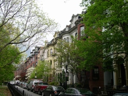
It started in the 1600s as nothing more than a large bay with a neck of land connecting Roxbury to Boston, but today the South End neighborhood represents the largest assembly of Victorian row homes in the United States. Partial filling-in of the bay created more land for development. Development began in earnest in the early 1800s after famed architect Charles Bulfinch laid out a plan for South End with a grid-pattern of streets, and parks containing trees and fountains. Reflecting the English system favoring open space, the South End evolved to include several parks surrounded by handsome brick town houses with bowed fronts. Italianate was the predominant style of these structures, with only subtle variations in style, building height, street width, and parking areas.
Merchants and other middle class residents became prevalent in 19th century South End after development in the surrounding areas attracted the aristocrats, but they in turn gave way to many immigrants and veterans by the mid 20th century. Diversity was a clear characteristic during this period, with residents including large populations of Jews, Syrians, Greeks, Italians, Portuguese, Chinese, West Indians, African-Americans, Native Americans, and Puerto Ricans.