City and State: Baltimore, Maryland
Listed: 1978
Type of district: National Register Historic District
Major Intersection: Frederick Avenue and Columbia Turnpike
Ellicott City National Register Historic District Report
Ellicott City National Register Historic District Map
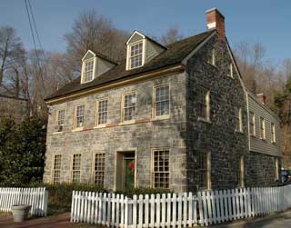
Ellicott City, originally Ellicott’s Mills, is located along the Patapsco River in Howard County, Maryland. It is an extremely well-preserved example of a 19th-century mill town, and traces its roots to three Quaker brothers – the Ellicotts – who in 1772 owned 700 acres of land along the Patapsco River. Successful businessmen, they helped to construct what is now the Old National Pike, a road that begins in Baltimore and extends west to Cumberland. The Ellicotts used the road to transport wheat from farms in the western part of the state to their mill along the river, and then transported the wheat by ship to their wharves at Baltimore’s harbor.
The wheat mill and the presence of other businesses along the Patapsco River prompted the Baltimore and Ohio Railroad to open an Ellicott City depot in May of 1830, further facilitating the transportation of goods and enhancing the prosperity of the town. In 1840, the Ellicotts began selling their property off as lots and the town began to take shape as a residence for workers, most of whom worked in textile factories that once stood along the river.
The name of the town was changed to Ellicott City in 1857. Its position above the Patapsco River, its sloping streets, and the predominance of granite used in the construction of its buildings make Ellicott City reminiscent of an English industrial town. Its well-preserved structures are vernacular interpretations of national styles.