City and State: Baltimore, Maryland
Listed: 1974
Type of district: National Register Historic District
Major Intersection: Woodlawn and Kenwood Roads
Roland Park National Register Historic District Report
Roland Park National Register Historic District Map
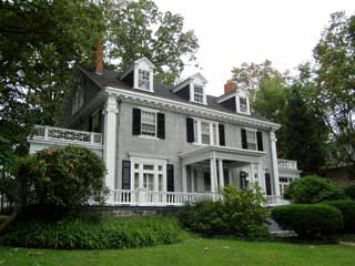
Roland Park is a planned garden suburb community located in the northern part of Baltimore. It was founded by the Roland Park Company in 1890 on 100 acres of land purchased from an Englishman named Roland Thornberry. The Company brought in a topographical and landscape engineer to lay out the streets and lots in accordance with the land’s hills, valleys, streams and woodlands. Every effort was made to protect the trees and natural vegetation of the site by laying the roads around them, and by having the roads follow the site’s natural contours.
The Company sold the lots with restrictions on them to preserve the character of the area. The restrictions included a provision for setbacks and planting, prohibited outbuildings and stables, and required the Company’s approval of all architectural plans prior to construction. The restrictions also required buyers to pay a maintenance fee to the Company to finance the upkeep of the public streets and sidewalks.
These restrictions are still in effect today, and have become the model for similar covenants in other communities. They have helped to preserve the integrity of this historic district, which continues to maintain a unity of architecture, landscape, lot size, house placement, and workmanship consistent with the developers’ original intentions for the site.